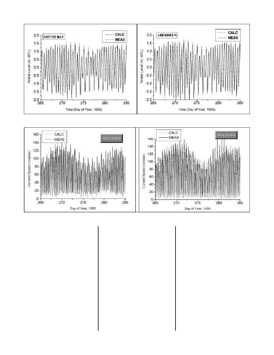
Figure 4. Measured water levels and ADCIRC model results at bay stations 2 and 4
Figure 5. Measured currents and ADCIRC model results at inlet stations 2 and 4
10 deg west of north to align the
of 40-42 m. One-dimensional fre-
application did not consider
wind-wave growth because the 9-km
longshore axis with the offshore
quency spectra from the CDIP
bathymetric contours (Figure 7). The
datawell buoy at Grays Harbor
fetch had a limited effect on wave
height, typically less than 15 per-
STWAVE grid had 341 cells in the
(03601) were obtained from the
cross-shore direction and 588 cells
CDIP Web site. A theoretical direc-
cent.) Bathymetric data were
in the longshore direction with a cell
tional spread was applied to the fre-
obtained from the U.S. Army Engi-
size of 50 x 50 m.
quency spectra to create 2-D spec-
neer District, Seattle, 1999 annual
tra for input to the STWAVE model.
survey and from the GEOphysical
STWAVE simulations of the first
The two-dimensional spectra were
DAta System GEODAS database of
month (11 September 14 October)
rotated 10 deg west of north to cor-
Hydrographic Survey Data (National
of the 2-month period of field-data
Geophysical Data Center of National
respond with the grid orientation.
collection (11 September through 17
Tide elevation data from water level
Oceanic and Atmospheric Adminis-
November 1999) were accomplished
station 1 were used to modify depth
tration (NOAA)). The vertical datum
by driving the model with the Grays
for each 3hr time period to account
was adjusted from mean lower low
Harbor Coastal Data Information
for water level (and depth) fluctua-
water to mean tide level with the
Program (CDIP) buoy wave spectra
tions of the tide.
Westport (Figure 1) tidal benchmark
at 3-hr intervals. The CDIP buoy is
adjustment of 1.5 m. Tidal elevation
located at 46 51.47' north latitude
Model validation with the field
data were added to the mean tide
and 124 14.64' west longitude,
data shows good correlation. A pre-
level bathymetry for each simulation
liminary comparison of wave height
approximately 9 km southwest of the
where the influence of tide level was
at seven wave gauge locations
entrance to Grays Harbor in a depth
considered. The grid orientation is
31


 Previous Page
