

Submerged Narrow-Crested Breakwaters
707
Scour
Scour was measured at the landward base of the reef struc-
ture. The scour was limited to a zone of 15 to 18 m (49 to 59
ft) landward of the reef with a depth varying between 1.2 m
(4 ft) in November 1994 to 2.1 m (6.9 ft) in July 1996 (HER-
RINGTON and BRUNO, 1998).
Wave Attenuation
Wave attenuation was not measured at the Belmar/Spring
Lake site.
Project Performance
No final report was available on the Belmar/Spring Lake
site. From the preliminary reports BRUNO et al. (1996a) and
HERRINGTON and BRUNO (1998), the shoreline was qualita-
tively reported as moving landward as the trucked beach fill
moved from the upper berm to form a bar in the nearshore
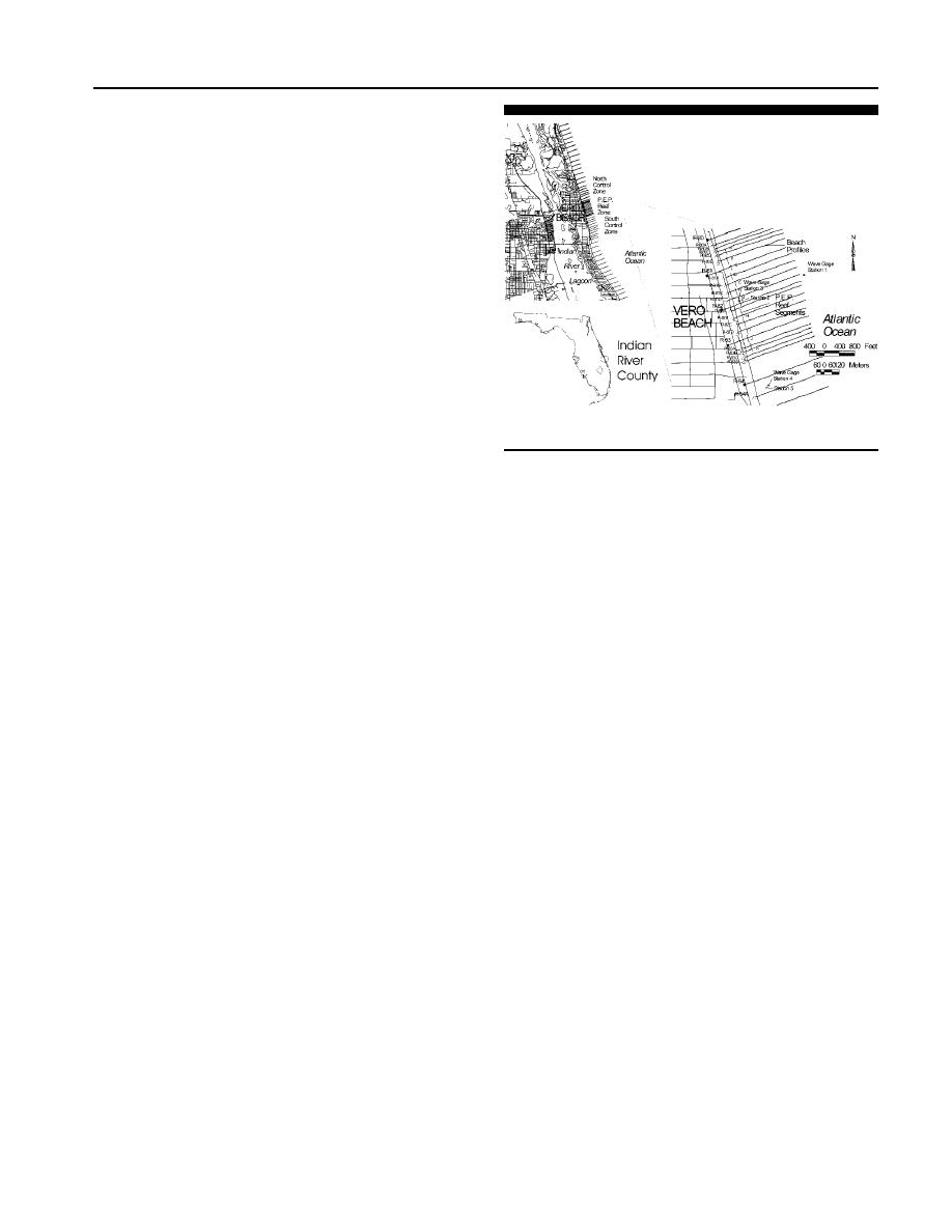
Figure 23. Location of the P.E.P. Reef installation at Vero Beach, Flor-
area landward of the reef structure, while the unfilled control
ida.
area groin compartment to the north remained relatively sta-
ble. The net volume of the profiles within the groin compart-
ment was basically conserved as the profile was reshaped.
With the use of a thick filter fabric as a base along with a
its coastline in the past. Erosion of concern occurs particu-
stone filled geotextile mattress, the settlement was reduced
larly along the shorefront of the City of Vero Beach. The
with most of the settlement measured in the center of the
coastline of Indian River County has few erosion control
groin compartment. A scour trench did develop on the land-
structures. There are currently 34 structures, totaling 1,741
ward side of the reef structure in spite of the geotextile mat-
m (5,711 ft) of shoreline (about 5% of the county's shoreline)
tress. The seaward side did not show any scour trench de-
armored with seawalls. The main concentration of seawalls
velopment. The design of this installation placed the Beach-
fronts the commercial district within the City of Vero Beach.
saver Reef across the entire groin compartment with attach-
The rest of Indian River County's shoreline is backed by a
ment to the groins on either side with caprock. The reef crest
coastal dune with a crest height around 4.6 m (15 ft). These
was at an intermediate depth relative to the other two New
seawalls, constructed of various designs and materials rang-
Jersey installations. To date this reef structure remains in
ing from vertical concrete to metal sheet pile were built over
place.
the years to protect upland property from wave damage dur-
ing storms. Between Florida Department of Environmental
VERO BEACH, FLORIDA, PROJECT
Protection (DEP) Range monuments R-80 and R-83, approx-
The final installation of the P.E.P. Reef was in August 1996
imately 95% of the shoreline is backed by coastal armoring
at Vero Beach, Florida. Indian River County is located on the
structures. This is the area of P.E.P. Reef installation.
central Florida Atlantic coast, approximately 97 km (60
To mitigate erosion, a 914 m (3,000 ft)-long submerged
miles) south of Cape Canaveral. The City of Vero Beach, oc-
P.E.P. Reef was placed by Indian River County, along the
cupies 6.3 km (3.9 miles) of beach along a 35-km (22-mile)
shoreline of the City of Vero Beach between 20 July and 15
long barrier island coast some 24 km (15 miles) south of Se-
August 1996. A total of 217 interlocking P.E.P. Reef units
bastian Inlet and 21 km (13 miles) north of Ft. Pierce inlet
were placed in an alternating onshore/offshore configuration
(Figure 23). A naturally occurring, discontinuous, nearshore
with gaps between each segment. This alternating placement
reef system composed of coquina beachrock (containing most-
design is approximately 61 to 76 m (200 to 250 ft) seaward
ly broken shell fragments and quartz sand grains cemented
of the beach, and extends from DEP monument R-80C to R-
together) is found in the nearshore. This reef is part of the
83B. This modified project placement configuration with gaps
Anastasia Formation (a long, narrow linear rock formation)
between shorter segments was determined by wave tank
which extends south from Anastasia Island (St. Augustine)
studies and the experience gained with the measurement of
some 322 km (200 miles) to Palm Beach (STAUBLE and
inshore face scour on the single line configuration of the Mid-
MCNEILL, 1985). The nearshore reef formation is around 305
town Palm Beach project (DEAN et al., 1994b). The break-
to 610 m (1000 to 2000 ft) wide, parallels the shoreline and
water consists of eleven segments (AK) ranging in length
is found in the surf zone along almost the entire length of
from 51 to 93 m (168 to 304 ft), placed in a configuration as
shown in Figure 23. Design bottom elevations were 2.1 m
Indian River County. The rock may be covered with sand at
( 7 ft) for inshore units and 2.7 m ( 9 ft) for offshore units.
some times of the year and outcrops as bare rock at other
times. The rock reef structure starts just south of Sebastian
This placement would provide design water depths above the
Inlet and becomes exposed at low tide at Riomar Point.
inshore unit crests of 0.3 m (1 ft) NGVD and above the off-
Indian River County has experienced erosion along most of
shore units of 0.9 m (3 ft) NGVD.
Journal of Coastal Research, Vol. 19, No. 3, 2003

 Previous Page
