U.S. Army Engineer District,
Research and Development Center
or preproject monitoring records, and
Philadelphia, Cape May Pont, NJ.
(ERDC) staff) reviewed the submit-
have identifiable spatial and tempo-
The borough of Cape May Point, NJ,
ted site nomination packages and
ral scales associated with localized
was specified in the appropriations
identified specific sites appropriate
coastal processes.
language of Section 227. Cape May
for further consideration. Thirty-
Selection criteria for demonstra-
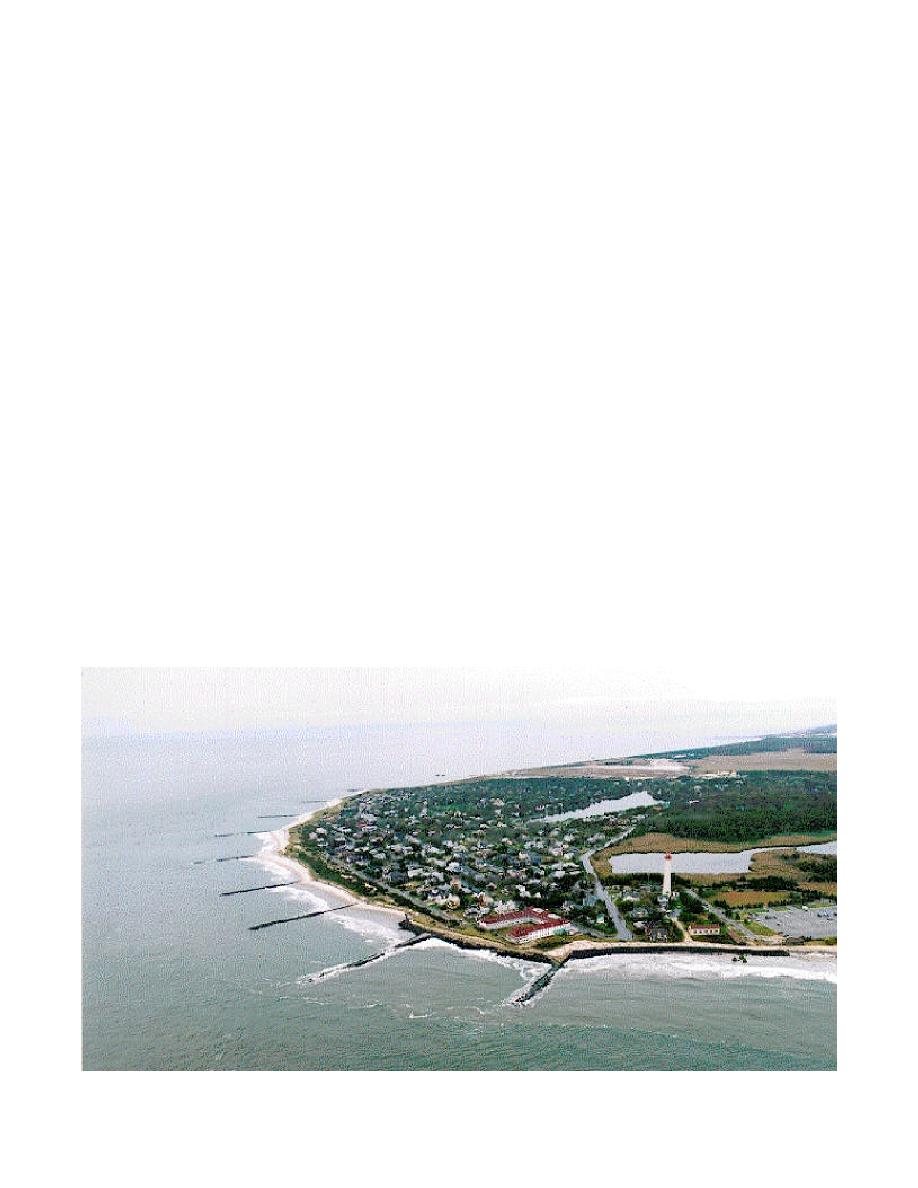
Point is a 1.8-km-long beachfront
seven nomination packages were
tion technologies include applicability
community located on the southern
originally submitted by 17 coastal
to project site, suitable and quantifi-
tip of New Jersey. Cape May Point
Corps Districts. Technological
able performance prediction metrics,
is particularly vulnerable to storm
advancements will be selected for
sound engineering design, and eco-
damage due to exposure to waves
demonstration by the committee
nomic feasibility of construction and
from both the Atlantic Ocean and
based on scientific and engineering
maintenance. Specific technologies
the Delaware Bay. Existing shore
validity and on economics. Perfor-
identified as having a high priority
protection structures along the
mance of the applied technologies
for testing include innovative groin
shoreline at Cape May Point include
will be evaluated as related to inter-
geometries and permeable groins,
a series of nine groins with a spac-
action with the coastal system and
reef breakwaters and breakwater
ing that varies from 150-300 m, and
other engineering considerations
configuration, armoring alternatives,
a rubble revetment armoring the
such as constructability, structural
bioengineered and vegetative
shoreline in the easternmost groin
stability, and life-cycle costs. The
approaches, cohesive and bluff
cell (Figure 1). While these engi-
performance of all demonstration
shore treatments, and other sand
neered efforts have "held the line" in
projects will be monitored under
retention methods and site manage-
most sections with regard to erosion,
Section 227 for a minimum of
ment strategies. All demonstration
that "line" is at a critical position and
3 years. Evaluation of functional per-
projects must meet local permitting
the width of the back beach is
formance will be documented and
and regulatory requirements.
severely compromised. There is vir-
widely disseminated to the coastal
Nominations for demonstration
tually no buffer from storm events
engineering community.
sites and technological applications
that can severely damage the area,
are being coordinated through the
and this absence also contributes to
Project Implementation,
coastal U.S. Army Corps of Engi-
saltwater intrusion of a nearby criti-
neers (USACE) District and Division
cal freshwater wetland.
Fiscal Year 2000
offices. The Section 227 oversight
The compartmentalized beach at
committee (consisting of the civilian
Cape May Point presents an oppor-
During fiscal year 2000, primary
members of the Coastal Engineering
tunity for researchers to evaluate the
sites were selected for project imple-
Research Board, USACE Headquar-
effectiveness of narrow-crested sub-
mentation plan development
ters and U.S. Army Engineer
merged breakwaters such as the
including:
Figure 1. Borough of Cape May Point, NJ. Narrow-crested submerged reef structures (BeachsaverTM) will enclose groin cells
to be used to retain beach-fill material
2


 Previous Page
