692
Stauble and Tabar
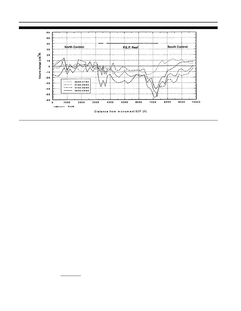
Figure 8. Comparison of the annual volumetric changes at Midtown Palm Beach, Florida (after Dean and Chen, 1996).
(DEAN and CHEN, 1995c). The units installed in 1992 reached
where, KT is the transmission coefficient, Hs nearshore is the
an equilibrium depth within the first 5 to 6 months after
nearshore significant wave height, and Hs offshore shoaled is the
placement, responding to the effects of Hurricane Andrew
offshore significant wave height shoaled in accordance with
(Figure 12). The units placed in 1993 took around 18 months
linear wave theory to the location of the nearshore gage
to reach a constant depth. The rate of settlement was most
(DEAN and CHEN, 1995c). There was much scatter in the data
rapid within the first three months after placement. All of
due to differences in daily tide levels, resulting in more trans-
the units were placed on a sandy substrate although there is
mission during high water periods. Additionally, larger off-
hardbottom consisting of coquina beach rock under the sand
shore wave heights caused less transmission, and loss of
in this area.
beach landward of the reef structure caused greater reflection
from seawalls and revetments at the landward end of the
beach profiles. For the period between December 1993 and
Scour
July 1995, the wave transmission coefficients ranged from
Measurements were made on the 28 scour rods placed in
0.62 to 1.17 (DEAN and CHEN, 1995c). Periods when there
various locations around the reef on six different periods from
were higher waves, the transmission coefficients averaged
29 July 1993 to 24 June 1995. Scour ranged from 38 to 99
around 0.76 and during periods of lower waves the coeffi-
cm (15 to 39 inches) over the last monitoring period from
cients were around 0.87. Two control wave gages were also
September 1994 to June 1995 (DEAN and CHEN, 1995c). An
in operation for a short 15 day period at a location 152 m
average rate of scour was given as 0.13 m/month (0.43 ft/
(500 ft) south of the reef installation and measured wave at-
month) at scour rods 14 to 19 at the north end of the south
tenuation over the natural bottom. From a comparison of the
breakwater and in the gap between the two reefs. Less scour
wave attenuation of the control gages, there was an energy
was measured in the center of the longer reef section than at
loss between 5 and 15% over the natural bottom (DEAN and
the ends. The southern control scour rods showed about the
CHEN, 1996). It was determined that the P.E.P. Reef associ-
same magnitude of scour as the ends of the reef sections, but
ated transmission coefficients ranged from 85 to 95% (DEAN
the north control had less scour than the reef area. While
and CHEN, 1995c).
there was a large scattering of the scour data, scour was mea-
sured at all of the rod positions.
Project Performance
Wave Attenuation
The trend exhibited in the Midtown Palm Beach applica-
tion of the P.E.P. Reef showed that the area south of the reef
To determine the effectiveness of the P.E.P. Reef in reduc-
and in the lee of the reef experienced erosion. The shoreline
ing wave height, wave data was analyzed from the two wave
also retreated in theses areas. The project monitoring docu-
gages on the landward and seaward sides of the reef struc-
mented that the area behind the reef lost large amounts of
ture. Wave transmission coefficients were given as:
sand within the first four months of the full project instal-
Hs nearshore
lation, while both north and south control zones gained sand
(1)
KT
Hs offhsore shoaled
(DEAN et al., 1994a). The trend continued during the entire
Journal of Coastal Research, Vol. 19, No. 3, 2003


 Previous Page
