Submerged Narrow-Crested Breakwaters
713
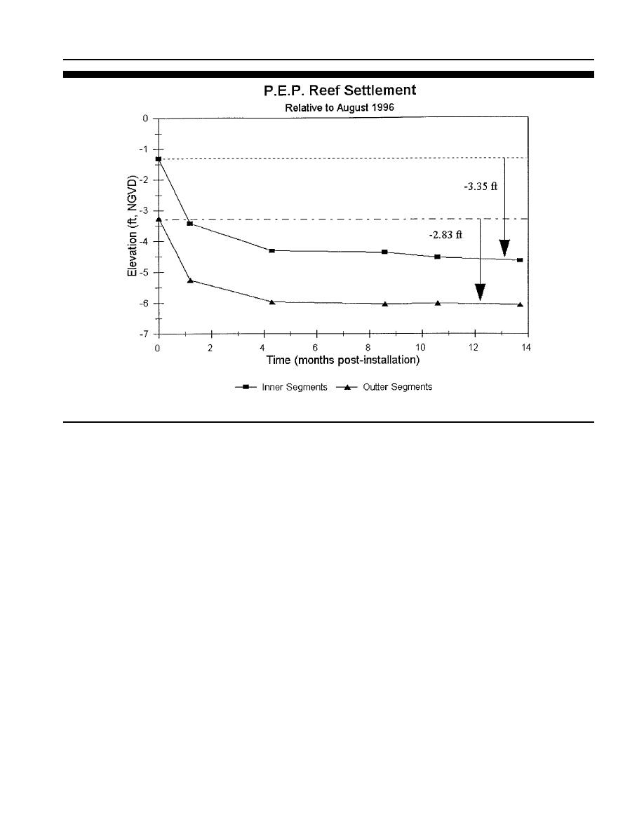
Figure 27. Average settlement after 14 months of the inner and outer P.E.P. Reef segments relative to initial installation in August 1998 at Vero Beach,
Florida. (Stauble et al., 2000.)
Project Performance
beach backed by dunes. The nearshore natural hardbottom
has a distinct two shore-parallel reefs separated by a sedi-
The trend of the shoreline and volume change for the initial
ment-filled trough. This zone was generally accretionary. The
34-month period was for seaward movement of the shoreline
sand volume gain in this zone was mainly on the subaerial
and gain in volume for the north control area. Landward
beach and foreshore area. Little change was measured in the
movement of the shoreline and loss in profile volume was
nearshore. The north end of the P.E.P. Reef appeared to act
measured in the P.E.P. Reef zone, and a slight seaward move-
as a groin trapping sand in the north control and restricting
ment of the shoreline and a slight gain in volume was found
its movement to the south (direction of net drift). The P.E.P.
in the south control area. The south control area showed the
Reef zone is characterized by narrow beaches backed by var-
most fluctuation between landward and seaward shoreline
ious types of seawalls that are irregularly aligned. The high
movement, and gain and loss of profile volume of the three
water line is commonly at or past the base of most of the
zones over time. There were no strong seasonal trends in ei-
seawalls, so the beach is intertidal. Within this zone, the
ther the shoreline or volume change. With the large accretion
nearshore natural hardbottom morphology is characterized
experienced in the December 1999 survey, the P.E.P. Reef
by three distinct natural reef structures extending out in a
shoreline moved seaward of the north control but was still
southeasterly direction from the shoreline. A single natural
landward of the south control. With the large accretion over
reef outcrop is offshore and parallel to the coast. Pockets of
almost the entire 45-month study period in the north control
sand are found between two shore attached reef lines. The
zone, the cumulative shoreline moved further seaward than
P.E.P. Reef segments were placed in this zone along two lines
the other zones. As of the December 1999 survey, the shore-
paralleling the shoreline in 2.13 and 2.74 m ( 7 and 9
lines in the P.E.P. Reef and south control zone also moved
ft) of water. Some of the reef segments were placed on sand
seaward. Although accretionary between December 1999 to
and some on outcropping hardbottom. Throughout the study,
June 2000, the P.E.P. Reef zone, usually had the most land-
these beaches, were most erosive, especially in the north part
ward shoreline position of the three zones. The south control
of the P.E.P. Reef zone. The short profile and the interaction
shoreline position was stable, with minor seaward movement
of waves directly on the vertical face of the seawalls, espe-
over the study duration.
cially during periods of raised water levels, prevented sand
The change in the beach profiles within the three zones is
from accumulating in large volumes. At the end of the study,
a result of several factors. The north control area is a wide
Journal of Coastal Research, Vol. 19, No. 3, 2003


 Previous Page
