

Submerged Narrow-Crested Breakwaters
699
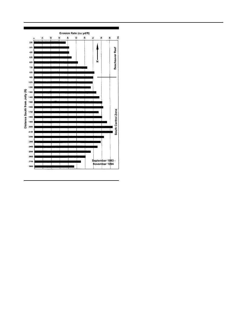
an average of 181 cu m/m (72 cu yd/ft) between September
1993 and November 1994. The beach near the southern end
of the Beachsaver Reef experienced erosion of 156 cu m/m (62
cu yd/ft) and the northern end of the reef measured an av-
erage of 100 cu m/m (40 cu yd/ft). This northern end was
closed by the jetty and it may have provided protection to
this beach from the inlet wave and tidal current interactions
(BRUNO et al., 1996a). FARRELL (1995) reported that the reef
trapped sand along its seaward face along the entire length
of the structure. Some sand was possibly moved seaward in
a narrow gap in between the 8th Street jetty and the north-
ern end of the Beachsaver Reef. These reef units have settled
from 0.61 m (2 ft) on the northern end to 1.22 m (4 ft) on the
southern end (BRUNO et al., 1996a). Scour was also found
along the landward side of the reef structure (FARRELL,
1995). A pronounced scour zone developed within 12.19 m (40
ft) of the inshore face of the reef, with a depth of scour reach-
ing 1.22 m (4 ft) (BRUNO et al., 1996b). Sand loss was also
reported at times south of the southern end of the reef struc-
ture. The location of the installation was strongly influenced
by inlet processes with strong flood-dominated tidal currents
flowing parallel to the reef structure. The Beachsaver Reef
at this location was reported to be only partially successful
in that it reduced beach erosion only on the enclosed north
end, but since no negative impacts were measured, it was
recommended to leave the structure in place (BRUNO et al.,
1996b).
CAPE MAY POINT, NEW JERSEY, PROJECT
In May 1994, a 305 m (1,000 ft) long Beachsaver Reef was
installed at Cape May Point, NJ as a continuation of the
State of New Jersey Pilot Reef Project. This location is
Figure 15. Average erosion rates at Avalon, New Jersey, Beachsaver
around 96 km (60 miles) south of Atlantic City. Cape May
site (after Bruno et al., 1996b).
Point is the southernmost beach in New Jersey. The beach
fronts on the Atlantic Ocean at the entrance to Delaware
Bay. Strong tidal currents flowing around the point in the
exceeded 0.8 times the water depth or 6.5 times the offshore
Cape May Channel just offshore have scoured the shoreline
significant wave height there was total wave transmission.
requiring the construction of nine timber and stone groins
perpendicular to the shore around 122 m (400 ft) in length to
Dye and Current Studies
help stabilize the beach (HERRINGTON and BRUNO, 1998).
The dye study in November 1993 compared the release of
Net drift direction is from east to west toward Delaware Bay.
dye behind the reef with an area south of the reef. The study
Chronic erosion to the east at Cape May Meadows and the
was conducted on a calm day with little wind. The tidal cur-
State Park has limited updrift sediment input to the groin
rents seemed to control the flow dispersion, with the first
system. There is little sand transport between the eight ap-
readings taken at the beginning of a ebb tide. The dye behind
proximately 152 to 183 m (500 to 600ft) wide groin compart-
the reef indicated a dominant offshore inlet-directed flow
ments, with most of the sand transport in the offshore direc-
while the control area to the south showed a dominate south-
ward wave induced longshore current (BRUNO et al., 1996b).
1997). In an effort to mitigate for the offshore sand loss, the
A further study of currents measured with the electromag-
Beachsaver Reef was installed between the Lehigh Avenue
netic current meters on 23 May 1995 indicated that the inlet
groin, Whilldin Avenue groin and the Coral Avenue groin in
tidal currents were the dominant feature in the circulation
groin compartments 2 and 3 (Figure 17). The structure was
near the reef structure.
constructed in two segments of 50 Beachsaver units each,
around 137.2 m (450 ft) long to connect the seaward end of
Project Performance
all three groins. A jack-up barge was used to place the indi-
vidual concrete reef units. Capstone was used to connect the
Profile analysis indicated that the Avalon shoreline re-
ends of the breakwater with the groins. The objective was to
turned to a pre-project position by May 1995. The area of the
provide protection for the two pocket beaches between the
beach fill south of the Beachsaver Reef and ocean outfall lost
Journal of Coastal Research, Vol. 19, No. 3, 2003

 Previous Page
